Welcome note

When my husband and I set out to find and take pictures of wheelchair accessible waterfalls in every U.S. state, we were excited about the challenge. We gave ourselves no time limit to accomplish our feat; however, we had one mutually agreed upon rule that dictated how long we would stay in any given area. That rule was to never shiver again. Needless to say, adhering to this rule presented a new challenge. The new challenge was to find a waterfall that was actually flowing. Visiting mid-west and eastern states during months that prevented us from shivering are the same months that are hot enough to dry up streams; hence, little or no water flow for waterfalls. The natural scenery and picturesque landscapes warrant a second visit in the early spring right after the snow melts.

Bob and Jan

Bob and Jan
Christmas Eve

Total Pageviews

Thursday, September 29, 2016

NIAGARA FALLS - Niagara Falls State Park, New York


DESCRIPTION:  Lake Superior, Lake Michigan, Lake Huron, and Lake Erie overflow into Lake Ontario. About 150,000 gallons of water/second floods over the America side of Niagara Falls. The height is 176 feet.  Niagara Falls State Park is the oldest state park in America.

Besides the spectacular scenic views of the falls and the experience of the mist at many points in the park or hearing the Fall's roar which makes it nearly impossible to carry on a conversation in a normal voice volume, the park offers dining, Cave of the Winds tour, Legends of
Adventure movie (meet daredevils traversing the Falls), sea life at the Aquarium of Niagara, and boat rides to the bottom of the Falls on "Maid of the Mist", as well as a touring shuttle.

In the late 1860's, a small group of environmentalists founded the Free Niagara movement. The movement wanted the natural beauty of the land surrounding the falls to be protected and remain free to the public. The entire network of paths through the wooded areas and along the banks of Niagara River stays maintained and preserved. Even though the park entrance is free, a $10 parking fee is due upon exiting.
 
 TYPE:   Plunge: Water descends vertically, losing contact with the bedrock surface.  Block: Water descends from a relatively wide stream or river.
 
ACCESSIBILITY:  Wheelchairs and strollers are available at the welcome center.  Level pathways and elevators are available for easy access to anywhere in the park. The trolley and "Maid of the Mist" are accessible for wheelchairs. The 230-foot Observation Deck has elevators to the top overlook and to the base of the falls. Accessible pathways lead to the base of the falls to experience the massive amounts of mist.


DIRECTIONS:  After crossing Grand Island Bridge ($1 toll), take exit 21 to Robert Moses Parkway. Continue on the Parkway as it turns into Prospect Street. Follow the signs that direct you to Niagara Falls State Park parking lots.

Phone:  (716) 278-1796
Address:  Niagara Falls State Park
                332 Prospect Street
                Niagara Falls, NY  14303


Monday, August 15, 2016

KANAWHA FALLS - West Virgina


DESCRIPTION:  Kanawha Falls is located in an unincorporated community in Fayette County West Virginia.  The Falls is on the Kanawha River, 2 miles south of Gauley Bridge.

The Falls are a mere 15 feet high, but very wide.
  

ACCESSIBILITY:  A walking path leads to the old mill that sits on the edge of the Fall. Handicap fishing is available directly off of the parking lot which is positioned in front of the Falls.


TYPE: 
            Tiered: Water drops in a series of distinct steps or falls.


DIRECTIONS:  The Falls are right along US60. Drive south on US 60 for 21 miles; one-mile past Gauley Bridge. The red Kanawha Falls sign is well marked on the left; however, during the "rainy" season, you may sidetracked by the  small waterfalls on the left of the road (driving south). Be aware, you may fly right by the parking lot to Kanawha Falls.


MINNEOPA STATE PARK - Mankato, Minnesota

MINNEOPA FALLS STATE PARK - Mankato, Minnesota


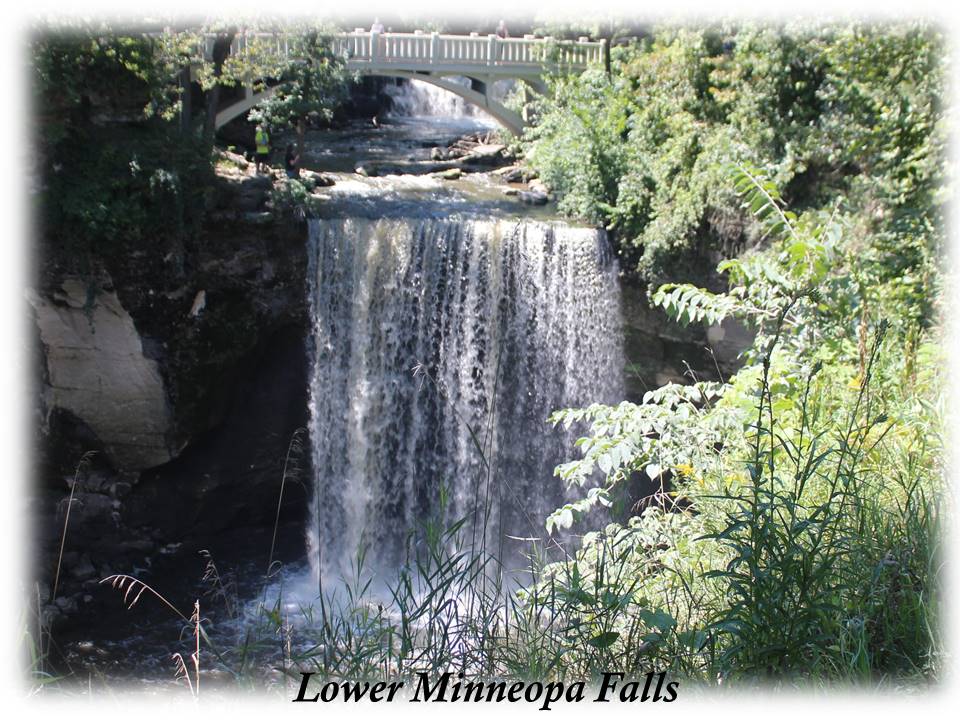
 Minneopa Falls are located inside Minneopa State Park in South Central Minnesota near Mankato and New Ulm.  The word "Minneopa" is Dakota language meaning "water falling twice" which explicitly describes the alluring double falls.  The upper falls drops 7-10 feet and the lower falls plunges 40 feet into a pool. The Minnesota River and Minneopa Creek flow through the park which are the source of the waterfall.

A $5 day pass is required for entrance into the park. A fee that is well worth the tranquil view and relaxation created by the sound of water spilling over rock formations. The park is open year-round from 8am-10pm.


ACCESSIBILITY:  A concrete trail leads directly from the gravel parking lot, past picnic areas with shelters and tables. Shaded areas with picnic tables and grilling areas are available also. The trail leads to a picturesque bridge that crosses the waterfall between the upper and lower fall. Following the path around a bend, a full scenic view of both the double fall and bridge can be seen. Clean bathrooms are available; however, the entrance is a tight squeeze for a wheelchair.


FALL TYPE:  Plunge - Water descends vertically, losing contact with the bedrock surface.

DIRECTIONS:  Drive west of Mankato on Highway 60 for 3.5 miles. Watch for the brown State Park sign. Turn right on Highway 68 and drive north for 1.6 miles to the park entrance.

EMAIL:  minneopa.statepark@state.mn.us

ADDRESS:  54497 Gadwall Road  Mankato, Minnesota  56001

PHONE:  (507) 389-5464
             

Saturday, July 23, 2016

CATARACT FALLS - Cloverdale, Indiana


DESCRIPTION:  Cataract Falls, located in a park in Indiana in a town named Cloverdale, Indiana (west central part), is the largest waterfall in Indiana. Two sets of falls on Mill Creek, the upper and lower fall, create a cascading fall that drops 86 feet. The upper fall drops 20 feet and the lower fall approximately a half mile away drops 18 feet.
ACCESSIBILITY:  Concrete paths with viewing areas lead directly from the parking lot to the upper falls. Picnic tables, shelters, and bathroom facilities are available at the upper falls. A short drive through the park takes you to a parking lot at the lower falls. There are no accessible paths to the lower falls; however, a grassy area isn't too bumpy for a wheelchair to cross for a closer look.


FEATURE:  A 140 foot covered bridge was built at the upper falls in 1876 and was open to traffic until 1988.


FALL TYPE: 
  • Plunge: Water descends vertically, losing contact with the bedrock surface.
  • Cataract: A large, powerful waterfall 
  • Cascade: Water descends a series of rock steps


FEE: The Cataract Park website stated there is a $5 fee unless you arrive before the park office opened. If so, you may enter the park free of charge. When we went the office looked deserted.

DIRECTIONS:  From I-70, drive south on US231 and Bloomington. Watch for signs to Cataract Falls. Turn on Cataract Falls road. Drive 3 miles. Cataract Falls is on the right. A large parking lot is directly off of the road. The park is open sun-up to sundown.

Thursday, July 14, 2016

BOND FALLS - Paulding, Michigan


DESCRIPTION:  Bond Falls, western U.P. Michigan, is in southern Ontonagon County. It falls over a thick formation of fractured rock. The total fall is approximately 50 feet; located in the middle branch of Ontonagon River.


ACCESSIBILITY:  Paved paths lead directly from the parking lot to a large boardwalk that raps from one side of the falls to the opposite side in a half moon shape.  Incorporated at six points on the horseshoe, three special viewing areas allow for seating or clear views. Able-bodied people can take steps to the top of the falls.


TYPE:  Cascade: Water descends a series of rock steps.

DIRECTIONS: In the town of Paulding, Michigan (unincorporated), turn off the main road (45) onto Bond Falls Road. Drive four miles to the Bond Falls sign located on the left side of the road.  A $9.00 day fee is required for out of state vehicles upon entrance: payable at the ranger's booth.

Bond Falls Road
Paulding Michigan  49912
906-353-6558

Tuesday, June 28, 2016

Tahquamenon Falls - Tahquamenon Falls State Park, Michigan


Tahquamenon (pronounced like phenomenon) Falls is located in the eastern upper peninsula of Michigan. Tahquamenon River flows into a bay on Lake Superior. It's copper color is caused by tannin from cedar swamps draining into the river.


Accessibility: Paved pathways lead to several viewing areas of the upper falls. Steps lead to the lower falls.
Fall Type: Plunge: Water descends vertically, losing contact with the bedrock surface. The fall is 200 feet across with a drop of 48 feet. The Fall is one of the most voluminous waterfalls east of the Mississippi River, with Niagara Falls being the most.

Directions: Follow M-123 north of Newberry, Michigan for approximately 22 miles. The Upper Fall Tahquamenon State Park sign is on the left. The park is located on the right. Out of state vehicles pay a $9.00 day-pass fee or $31.00 year-pass.

Thursday, June 23, 2016

THUNDER BAY FALLS GALENA, ILLINOIS

Very little information can be found about this Thunder Bay Falls in Galena, Illinois. Thank goodness for my talkative husband.  I have always called him Mayor Bob because he talks to everyone. We were ready to give up on finding a wheelchair accessible waterfall in Illinois until a fellow camper told us about this small town in the northwest corner of Illinois named Galena. We found one person in the town that knew of the waterfall. It is a gorgeous secret.


ACCESSIBILITY: A gravel path leads directly from the parking area. Without help from my husband, the gravel would make maneuvering a wheelchair difficult, but not impossible. Two paths to the front of the Falls; one directly in front of the Fall and one at a higher level in front of the Fall.


TYPE: The Falls is a cascading spillway from Lake Galena.

DIRECTIONS: 7998 W Glen Hollow Rd Galena, IL 61036 Turn off of US 20 onto Glen Hollow Road. Follow that winding road to the parking area. The Falls is located approximately 2 miles on Glen Hollow Road on the right hand side of the road.