Welcome note

When my husband and I set out to find and take pictures of wheelchair accessible waterfalls in every U.S. state, we were excited about the challenge. We gave ourselves no time limit to accomplish our feat; however, we had one mutually agreed upon rule that dictated how long we would stay in any given area. That rule was to never shiver again. Needless to say, adhering to this rule presented a new challenge. The new challenge was to find a waterfall that was actually flowing. Visiting mid-west and eastern states during months that prevented us from shivering are the same months that are hot enough to dry up streams; hence, little or no water flow for waterfalls. The natural scenery and picturesque landscapes warrant a second visit in the early spring right after the snow melts.

Bob and Jan

Bob and Jan
Christmas Eve

Total Pageviews

Sunday, December 27, 2015

Willow Falls - Willow River State Park, Wisconsin


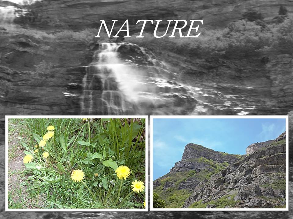
DESCRIPTION:  Willow Falls is a 45 foot cascading waterfall located in Willow River State Park northeast of Hudson, Wisconsin.

ACCESSIBILITY:  The falls are reachable by several different trails. The trails are accessible; however, they aren't easily accessible. The  shortest trail is on a 1/4 mile paved walking path; however, it is a steep trail.  The trail we took to the waterfalls was grassy in spots, deep gravel in other spots, then other spots had gouged out muddy areas. My husband and step-son took turns pushing my wheelchair over this terrain.  I could have never successfully mastered the feat alone.  When leaving the falls, we took the third trail.  This trail was about two miles, but, a bit smoother.  It was a dirt path, but well-worn because this path was used more frequently by the many people who visited the fall each day. Even though the trails left little-to-be-desired, the nature was worth the travel.

A sturdy bridge traversed the 100-foot wide waterfall. A parking fee is payable upon entering the park.

TYPE:  Cascading - follows along a series of rock steps

Sunday, September 20, 2015

BRIDAL VEIL FALLS - PROVO, UTAH

DESCRIPTION - Bridal Veil Falls is a 607 foot tall, double cataract fall in Provo Canyon, Utah. Until 2008 the tramway was heralded as the steepest aerial tramway in the world, but the cables were cut. The falls can be seen in several scenes in the 1982 movie Savannah Smiles. A year-round stream of water surges from a narrow point at the top from several springs.


 ACCESSIBILITY - Picnic tables are available in the park under shade trees and close to the falls. Paved paths make the short trek to the falls easy and casual. Bikers and skateboarders of all ages use the wide path for exercise as well.


  FALL TYPE - Cateract - A descent of water over a steep surface


DIRECTIONS -
  • Located up Provo Canyon (Hwy. 189) Provo, UT 84604
  • Phone: (801) 852-660

Sunday, September 13, 2015

RIFLE FALLS STATE PARK - RIFLE COLORADO

Description - Rifle Falls State Park is in Colorado NE of Rifle, Colorado. Thev48-acre park has a triple waterfall. The falls is a lush area of trees and greenery kept moist by the spray of the cascading triple waterfall (http://cpw.state.co.us/placestogo/parks/RifleFalls).  Mysterious limestone caves beneath the falls entice spelunkers and other curious visitors to explore their dark depths.Spray from the falls can be felt while picnicking at the tables near the falls.  


Accessibility - "In 1998, the park underwent a face-lift: new pavement, picnic tables, interpretive signs and increased handicapped access." The trek to the falls is only a short jaunt from the parking lot. 


Address and directions -  Follow the signs from town. The park is 13 miles north of town. A small fee is required to enter the park. Camping by tent or RV is available. Park Office5775 Highway 325 Rifle, CO, 81650  Park Hours - 7AM -10PM. Anglers And Campers Have 24 Hour Access Office HoursVaries - Can Visit Rifle Gap's Office For Needs 7am - 7pm Daily. Phone - (970) 625-1607 EmailRifle.Gap.Park@State.Co.Us 

Fall Type - a triple 70-foot waterfall flowing over a travertine (a mineral formed by a compilation of hots or spring waters) dam on East Rifle Creek.

Nature 


Friday, August 14, 2015

PIPESTONE NATIONAL MONUMENT-MINNEWISSA FALLS-MINNESOTA

Pipestone National Monument offers a three-quarter mile trail through the prairie, by quarries, and in front of Minnewissa Falls. Only people of Native American ancestry with a special permit can quarry the area or remove any stone.

WATERFALL TYPE:  Ledge waterfall: Water descends vertically over a vertical cliff, maintaining partial contact with the bedrock


ACCESSIBILITY:  A paved path throughout the park allows a wheelchair user easy access to view the beauty; however, a few places are narrow or a little steep that require assistance from another person.


DIRECTIONS:  Pipestone National Monument is easily accessible from the following highways. When you reach the city of Pipestone, road signs will lead you to Pipestone National Monument.
  • I-90 Luverne, MN Exit north on US Highway 75 to Pipestone, MN - 25 miles
  • I-90 north on MN Highway 23 to Pipestone, MN - 27 miles.
  • Marshall, MN, southwest on MN Highway 23 to Pipestone, MN - 45 miles.
  • Slayton, MN, west on MN Highway 30 to Pipestone, MN - 29 miles.
  • Lake Benton, MN, south on US Highway 75 to Pipestone, MN - 19 miles.
  • I-29 north of Sioux Falls, SD to Exit 109 (Madison/Colman exit) go east on SD Hwy 34 which becomes MN Hwy 30 to Pipestone, MN - 55 miles
  • I-29 Brookings, SD exit, go east on Hwy 14 to Lake Benton, MN, south on US Highway 75 to Pipestone, MN.


Monday, July 20, 2015

FALLING WATERS, OZARKS NATIONAL FOREST-ARKANSAS

DESCRIPTION: This beautiful little waterfall is conveniently located right next to the road, so you don't even have to get out of your car to see it. A narrow dirt path leads to a nice big pool that the falls spill into, and it is a popular swimming hole in the summer.


DIRECTIONS:  At the junction of Scenic 7 Byway and Ark. 16 at Pelsor, turn east on Ark. 16 to Ben Hur, then go south about 1.5 miles until you reach Forest Service Road 1205. Turn east on this road and remain on it for approximately 3 to 4 miles. You'll be following Falling Water Creek and will come upon the falls to your right. They are easily visible from your vehicle.

ACCESSIBILITY:  The falls can be seen from your car directly off the side of the road. A small pull-off area is available with a narrow dirt path leading to the pool that the falls spill into. Getting to the pool would be difficult without assistance.

WATERFALL TYPE: Plunge-descends vertically, losing contact with the bedrock surface.


Sunday, July 12, 2015

BIG SPRING PARK - NEOSHO, MISSOURI

We happened upon this waterfall while searching for a church in the town of Neoshu, Missouri. The name of Neoshu is an Indian word meaning "clear or abundant" water. The downtown buildings are early 1800. It is a scene taken right out of civil war times.


ACCESSIBILITY:  Big Springs Park has well-maintained grassy areas and stone or concrete pathways. Neosho is known as "the flower box" city.  The Park's grounds have flowers planted in many beds and a wading pool, benches for relaxing while enjoying the flowers or watching the ducks.


Friday, July 10, 2015

GRAND FALLS - JOPLIN, MISSOURI


http://www.visitmo.com/grand-falls.aspx Grand Falls in Joplin Missouri is the largest continuously flowing waterfall in Missouri. Grand Falls normally plunges 25 feet over a ledge; however, the day of this photo session was a day after severe thunderstorms, tornadoes and flooding, hence the muddy waters and higher waters.
DIRECTIONS:  Off I-44, exit 6; south on Route 86 two blocks; west on Glendale Road 1.5 miles; south on Jackson across the low-water bridge; immediately west on Riverside Drive two miles; Grand Falls is on the right.
5400 S. Riverside Drive
Joplin, MO 64804
Phone: 800-657-2534
Dawn-dusk.

ACCESSIBILITY:  The waterfalls are directly off the side of the road.  There is a pull-off parking area that allows you to see the falls from your car or move closer over a gravel area.