Many waterfalls in the USA are not accessible by wheelchair. Bob, my husband, and I are traveling the USA to search for waterfalls accessible by wheels (wheelchairs, bikes, strollers).
Welcome note
When my husband and I set out to find and take pictures of wheelchair accessible waterfalls in every U.S. state, we were excited about the challenge. We gave ourselves no time limit to accomplish our feat; however, we had one mutually agreed upon rule that dictated how long we would stay in any given area. That rule was to never shiver again. Needless to say, adhering to this rule presented a new challenge. The new challenge was to find a waterfall that was actually flowing. Visiting mid-west and eastern states during months that prevented us from shivering are the same months that are hot enough to dry up streams; hence, little or no water flow for waterfalls. The natural scenery and picturesque landscapes warrant a second visit in the early spring right after the snow melts.
Bob and Jan
Christmas Eve
Total Pageviews
Showing posts with label USA waterfalls. Show all posts
Saturday, April 29, 2017
FALL CREEK FALLS - Fall Creek Falls State Park, Tennessee
The Fall Creek Falls State Park is 26,000 acres making it the largest state park in Tennessee. The park has more than 34 miles of trails, an Inn, 222 campsites and 30 cabins, playgrounds, picnic tables and pavilions, and a golf course. The State Park Environmental Education Center is the Nature Center at Fall Creek Fall offering hands-on environmental education, school programs, and overnight field trips.
Fall Creek Falls is one of the highest waterfalls in eastern United States. Of the four waterfalls within the park, Fall Creek Falls is the only wheelchair accessible falls.Fall Creek Falls is the highest waterfall east of the Rocky Mountains.
TYPE: Plunge: Water descends vertically, losing contact with the bedrock surface. The fall plunges 256 feet into a gorge.
ACCESSIBILITY: Handicap parking begins a short path leading to an overlook directly across the gorge looking at the front of the falls.
ADDRESS:
Fall Creek Falls Creek Park
2009 Village Camp Road
Spencer, TN 38585
PHONE: 423-881-5298
Tuesday, April 11, 2017
WILDCAT FALLS - South Carolina
Wildcat Falls, officially known as Greenville Wayside Park, ia divided into three tiers. All three are fed by Wildcat Branch Creek. The lower section called Wildcat Wayside Falls can been seen right off the Cherokee Foothills Scenic Highway in Greenville County. The fall drops 30-feet before spilling into a shallow granite pool.
ACCESSIBILITY: No hiking required. Roadside parking is available for all types of vehicles. Wheelchairs can pull right up to the waterfall pool. The fall can be seen from the side of the road; in fact, you don't even need to get out of the car.
If able, a few natural steps on the left side of lower falls leads to Middle Falls. Middle Falls cascades 10-feet. A shelter built in 1930 is located on the side of Middle Falls. The shelter was built by the Civilian Conservation Corp as a resting stop for traveling motorists.
TYPE: Tiered: Water drops in a series of distinct steps or falls.
Cascade: Water descends a series of rock steps.
DIRECTIONS: Drive 5 miles west from Greenville, SC on US 276. The waterfall is located on the right side of the road. The Wildcat sign is located on the right side of the road too.
ADDRESS: Geer Highway, Cleveland, SC 29635
Wednesday, March 22, 2017
TOCCOA FALLS - Georgia
Toccoa is a Cherokee word for "beautiful". Located on the campus of Toccoa Falls College campus in north Georgia, the 186-foot high waterfall is one of the tallest free-falling waterfalls east of the Mississippi. In fact, the fall is taller than Niagara Falls.
ACCESSIBILITY: The falls' access is through the Toccoa Falls gift shop. Open from 8:30am to sundown, the admission is nominal. Ticket prices are $2 for adults, $1 for seniors, and free for children (6 and under) and veterans. The walking path is slightly uphill with small crushed gravel. A golf cart is available to those who need extra assistance to the base of the falls.
TYPE: Plunge: Water descends vertically, losing contact with
the bedrock surface. The 186- foot vertical fall plunges into a green pool of water. The creek continues to flow throughout the 1,100 acre campus.
DIRECTIONS: At the entrance of the college, stop at the Security booth. The officer will guide you in the correct direction. Follow the small signs to the gift shop parking lot which has several handicap parking spots.
Thursday, March 16, 2017
HIGH FALLS - DuPont State Forest, North Carolina
High Falls is one of the 4 major waterfalls in DuPont State Forest in the Blue Ridge Mountains of North Carolina in Transylvania County on Little River.
The falls gradually flows over 125-feet of wide granite. The water stays on the rock for the entire drop.
TYPE:
- Cascade: Water descends a series of rock steps
- Fan: Water spreads horizontally as it descends while remaining in contact with bedrock
Contact Information
Mail:
Telephone:
Email:
Telephone:
Email:
DuPont State Recreational Forest
PO Box 300
Cedar Mountain, NC 28718-0300
Voice: 828-877-6527
Fax: 828-862-8531
Permits and reservations: 828-877-6527, ext. 242
dupontsf.ncfs@ncagr.gov
PO Box 300
Cedar Mountain, NC 28718-0300
Voice: 828-877-6527
Fax: 828-862-8531
Permits and reservations: 828-877-6527, ext. 242
dupontsf.ncfs@ncagr.gov
Saturday, March 11, 2017
GREAT FALLS NATIONAL PARK - Virginia
The Potomac River falls rapidly over steep jagged rocks and flows through the narrow Mather Gorge.
Great Falls Park is a 800-acre National Park along the Potomac River. The park is riddled with history; first known example of blasting powder used for engineering purposes, the C&O Canal, between 1906 and 1932, the Washington % Old Dominion Railway operated a trolley park at the Falls.
The remains of the 1785 Potomack Canal, the first canal in the United States that used locks to raise and lower boats, which connected the Potomac and Ohio Rivers. The C&O Canal Company created the water highway. The C&O (Chesapeake and Ohio) Canal towpath was used to ship goods to market.
The lock-keeper house was enlarged to accommodate a hotel and tavern to welcome Washingtonians in the 1870's to natural beauty.
ACCESSIBILITY: The park is open during daylight hours. The parking lot provides 200 spaces as well as handicap parking close to the snacking area and picnic tables.
Restrooms are available a short distance from the parking lot along the path to the lock-keeper house and the Falls.
FALL TYPE: Cascade
DIRECTIONS: VIA: I-495 :
Take exit 44 for VA-193 (Georgetown Pike). Turn right onto VA-193 west at the stop light at the top of the ramp. Drive about three miles and turn right onto Old Dominion Drive at the stop light. The entrance to the park is about one mile down the road.
Address: 9200 Old Dominion Drive
McLean, VA 22102
Mailing Address:
Great Falls Park
c/o Turkey Run Park
George Washington Memorial Parkway
McLean, VA 22101
McLean, VA 22101
Phone: (703) 757-3101 Visitor information
Sunday, January 15, 2017
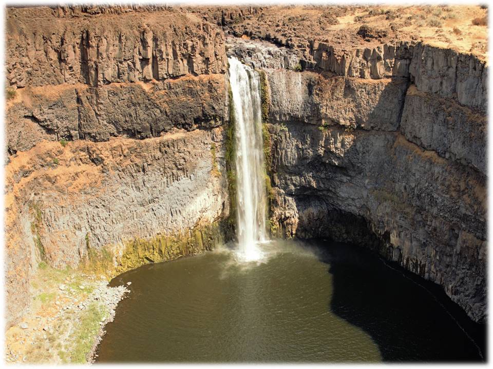
PALOUSE FALLS - Palouse Falls State Park, Washington
FALL TYPE: Lying on the Palouse River, plunge pool type Fall dumps 198 feet into a pool that flows into the Snake River.
INDIAN MYTH: Five giant Wolf brothers with spears fought Big Beaver (who stayed peacefully in its hole in the ground) killed giant Beaver. Mortally wounded, Beaver died thrashing and clawing the rock to gouge out the cliffs. When it died, its heart turned to stone.
ACCESSIBILITY: Trails for hikers lead to the base of the Falls. 0.5 miles of ADA paved paths lead to several overlooks, kiosks full of information about the park and the creation of the canyon, pit toilets, and unsheltered picnic tables.
DIRECTIONS: From Washtucna, drive SW on Main Street for 6.5 miles. Turn onto WA-261S. Follow the signs to Palouse Falls State Park. The highway winds through the country-side for 8.5 miles. You will think you are traveling incorrectly because the area is "open range". The Palouse Falls State Park road is on the left with a clearly marked sign. Travel 2.4 miles on a dirt and gravel road. The parking lot with handicap parking signs and restrooms are at the end of the road.
Saturday, November 26, 2016
KENT FALLS STATE PARK - Kent, Connecticut

This oldest state park in Connecticut was a gift to the state from the White Memorial Foundation in 1915.
The area is named "Sactacook" after a small Indian tribe that originated in Southwestern Connecticut.
ACCESSIBILITY: Handicap parking signs are at the head of the paved trail that leads through the covered bridge and onto the waterfall. At the base of the fall, a flat stone platform provides a serene view of the fall.
FALL TYPE: Cascade: Water descends a series of rock steps.
ADDRESS: 159 Macadonia Brook Road Kent, CT 06757
DIRECTIONS: North on Rte 7, 4.5 miles from Kent
Subscribe to:
Posts (Atom)