Welcome note

When my husband and I set out to find and take pictures of wheelchair accessible waterfalls in every U.S. state, we were excited about the challenge. We gave ourselves no time limit to accomplish our feat; however, we had one mutually agreed upon rule that dictated how long we would stay in any given area. That rule was to never shiver again. Needless to say, adhering to this rule presented a new challenge. The new challenge was to find a waterfall that was actually flowing. Visiting mid-west and eastern states during months that prevented us from shivering are the same months that are hot enough to dry up streams; hence, little or no water flow for waterfalls. The natural scenery and picturesque landscapes warrant a second visit in the early spring right after the snow melts.

Bob and Jan
Bob and Jan
Christmas Eve

Total Pageviews

Showing posts with label paved walking path. Show all posts

Sunday, June 25, 2017

CUMBERLAND FALLS - Cumberland Falls State Park, Kentucky

Cumberland Falls at Cumberland Falls State Resort Park is the largest fall east of the Mississippi River and south of Niagara Falls. It is 125-feet across and 68-feet high.
 The mist of Cumberland Falls creates a Moonbow which appears under a bright full moon and a clear sky. This moonbow is the only one in the western hemisphere. 

Visit Cumberland State Park's website for dates and times in which the moonbow may be visible.
ACCESSIBILITY: Several trails lead from the parking lot which has plenty of handicapped parking to various viewpoints.
TYPE:  
  • Plunge - water descends vertically, losing contact with the bedrock surface.
  • Block - Water descends from a relatively wide stream or river.
DIRECTIONS: Cumberland Falls is 15 miles southwest of Corbin. Take US 25W to KY 90. If traveling south on I-75, take Exit 25. If traveling north on I-75, take Exit 15.

Mailing Address:

CUMBERLAND FALLS STATE RESORT PARK
7351 Highway 90
Corbin  KY  40701-8857

Phone Number:

Information:  (606)528-4121

BRANDYWINE FALLS - Cuyahoga Valley Ohio


 Brandywine Falls is a National Park located in Cuyahoga Valley, Ohio. Brandywine Creek carved a 65-foot fall that cascades over layers of rock made of shales formed from mud on the sea floor that covered the area 350-400 million years ago into a gorge.

The moss, eastern Hemlocks, and Maple trees grow abundantly among the moistness of the gorge.


Accessibility: An ADA boardwalk leads to an observation deck at the top of the falls. Steps also lead to the bottom observation deck to be face-to-face with the powerful falls.

Handicapped restrooms are located directly off the parking lot.

Handicap parking signs designated for those with handicap placards are next to the restrooms and at the head of several walking trails and biking trails.

The biking trails are paved and worth the walk through scenic woods. Maps of the trails are available at a kiosk near the restrooms.


Type: Cascade - water descends a series of rock steps.

Address: 8176 Brandywine Road in Sagamore Hills Township

Phone: (303) 657-2752

Sunday, January 15, 2017

PALOUSE FALLS - Palouse Falls State Park, Washington


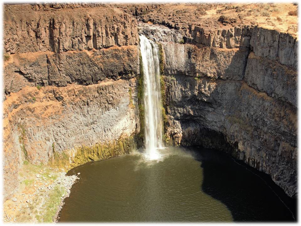
On February 12, 2014, Palouse Falls was deemed the official waterfall of Washington State. Meaning "Falling Water", named by the Palouse Indians, the Falls is located within the Palouse Falls State Park.


FALL TYPE: Lying on the Palouse River, plunge pool type Fall dumps 198 feet into a pool that flows into the Snake River. 
INDIAN MYTH: Five giant Wolf brothers with spears fought Big Beaver (who stayed peacefully in its hole in the ground)  killed giant Beaver. Mortally wounded, Beaver died thrashing and clawing the rock to gouge out the cliffs. When it died, its heart turned to stone.


ACCESSIBILITY: Trails for hikers lead to the base of the Falls. 0.5 miles of ADA paved paths lead to several overlooks, kiosks full of information about the park and the creation of the canyon, pit toilets, and unsheltered picnic tables.


DIRECTIONS: From Washtucna, drive SW on Main Street for 6.5 miles. Turn onto WA-261S. Follow the signs to Palouse Falls State Park. The highway winds through the country-side for 8.5 miles. You will think you are traveling incorrectly because the area is "open range". The Palouse Falls State Park road is on the left with a clearly marked sign. Travel 2.4 miles on a dirt and gravel road. The parking lot with handicap parking signs and restrooms are at the end of the road.


Saturday, November 26, 2016

KENT FALLS STATE PARK - Kent, Connecticut

Kent Falls is one of the most fabulous waterfalls in the New England states dropping 200 feet in 1/4 mile before flowing into the Housatonic River.


This oldest state park in Connecticut was a gift to the state from the White Memorial Foundation in 1915.


The area is named "Sactacook" after a small Indian tribe that originated in Southwestern Connecticut.

ACCESSIBILITY: Handicap parking signs are at the head of the paved trail that leads through the covered bridge and onto the waterfall. At the base of the fall, a flat stone platform provides a serene view of the fall.

FALL TYPE: Cascade: Water descends a series of rock steps.

ADDRESS: 159 Macadonia Brook Road  Kent, CT  06757

DIRECTIONS: North on Rte 7, 4.5 miles from Kent

Friday, November 25, 2016

GREAT FALLS - Paterson, New Jersey


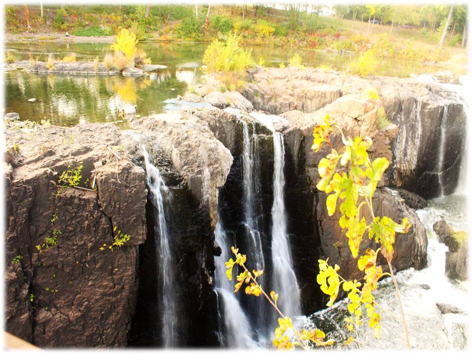
Amidst the town of Paterson, New Jersey, a 77-foot impactful waterfall on the Passaic River powers the Great Falls in Paterson National Historical Park. Alexander Hamilton proposed early development of the water power system for industrial use which began in 1792.


Great Falls is one of the largest waterfalls in eastern United States.


We captured the famous Fall's rainbow as we crossed the footbridge over the chasm. 


ACCESSIBILITY:  The parking lot on McBride Street offers handicap parking and ramps at designated handicap parking signs.sidewalks, ramps, and bridges circle the entire park. An accessible bridge crosses over the waterfall and gorge.


WATER SOURCE/FALL TYPE: Passaic River/Plunge: Water descends vertically, losing contact with the bedrock surface.


PHONE: (973)523-0370


ADDRESS:72 McBride Avenue, Patterson New Jersey

Monday, August 15, 2016

MINNEOPA STATE PARK - Mankato, Minnesota

MINNEOPA FALLS STATE PARK - Mankato, Minnesota


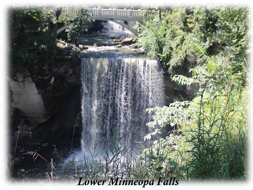
 Minneopa Falls are located inside Minneopa State Park in South Central Minnesota near Mankato and New Ulm.  The word "Minneopa" is Dakota language meaning "water falling twice" which explicitly describes the alluring double falls.  The upper falls drops 7-10 feet and the lower falls plunges 40 feet into a pool. The Minnesota River and Minneopa Creek flow through the park which are the source of the waterfall.

A $5 day pass is required for entrance into the park. A fee that is well worth the tranquil view and relaxation created by the sound of water spilling over rock formations. The park is open year-round from 8am-10pm.


ACCESSIBILITY:  A concrete trail leads directly from the gravel parking lot, past picnic areas with shelters and tables. Shaded areas with picnic tables and grilling areas are available also. The trail leads to a picturesque bridge that crosses the waterfall between the upper and lower fall. Following the path around a bend, a full scenic view of both the double fall and bridge can be seen. Clean bathrooms are available; however, the entrance is a tight squeeze for a wheelchair.


FALL TYPE:  Plunge - Water descends vertically, losing contact with the bedrock surface.

DIRECTIONS:  Drive west of Mankato on Highway 60 for 3.5 miles. Watch for the brown State Park sign. Turn right on Highway 68 and drive north for 1.6 miles to the park entrance.

EMAIL:  minneopa.statepark@state.mn.us

ADDRESS:  54497 Gadwall Road  Mankato, Minnesota  56001

PHONE:  (507) 389-5464
             

Saturday, July 23, 2016

CATARACT FALLS - Cloverdale, Indiana


DESCRIPTION:  Cataract Falls, located in a park in Indiana in a town named Cloverdale, Indiana (west central part), is the largest waterfall in Indiana. Two sets of falls on Mill Creek, the upper and lower fall, create a cascading fall that drops 86 feet. The upper fall drops 20 feet and the lower fall approximately a half mile away drops 18 feet.
ACCESSIBILITY:  Concrete paths with viewing areas lead directly from the parking lot to the upper falls. Picnic tables, shelters, and bathroom facilities are available at the upper falls. A short drive through the park takes you to a parking lot at the lower falls. There are no accessible paths to the lower falls; however, a grassy area isn't too bumpy for a wheelchair to cross for a closer look.


FEATURE:  A 140 foot covered bridge was built at the upper falls in 1876 and was open to traffic until 1988.


FALL TYPE: 
  • Plunge: Water descends vertically, losing contact with the bedrock surface.
  • Cataract: A large, powerful waterfall 
  • Cascade: Water descends a series of rock steps


FEE: The Cataract Park website stated there is a $5 fee unless you arrive before the park office opened. If so, you may enter the park free of charge. When we went the office looked deserted.

DIRECTIONS:  From I-70, drive south on US231 and Bloomington. Watch for signs to Cataract Falls. Turn on Cataract Falls road. Drive 3 miles. Cataract Falls is on the right. A large parking lot is directly off of the road. The park is open sun-up to sundown.

Thursday, July 14, 2016

BOND FALLS - Paulding, Michigan


DESCRIPTION:  Bond Falls, western U.P. Michigan, is in southern Ontonagon County. It falls over a thick formation of fractured rock. The total fall is approximately 50 feet; located in the middle branch of Ontonagon River.


ACCESSIBILITY:  Paved paths lead directly from the parking lot to a large boardwalk that raps from one side of the falls to the opposite side in a half moon shape.  Incorporated at six points on the horseshoe, three special viewing areas allow for seating or clear views. Able-bodied people can take steps to the top of the falls.


TYPE:  Cascade: Water descends a series of rock steps.

DIRECTIONS: In the town of Paulding, Michigan (unincorporated), turn off the main road (45) onto Bond Falls Road. Drive four miles to the Bond Falls sign located on the left side of the road.  A $9.00 day fee is required for out of state vehicles upon entrance: payable at the ranger's booth.

Bond Falls Road
Paulding Michigan  49912
906-353-6558

Sunday, December 27, 2015

Willow Falls - Willow River State Park, Wisconsin


DESCRIPTION:  Willow Falls is a 45 foot cascading waterfall located in Willow River State Park northeast of Hudson, Wisconsin.

ACCESSIBILITY:  The falls are reachable by several different trails. The trails are accessible; however, they aren't easily accessible. The  shortest trail is on a 1/4 mile paved walking path; however, it is a steep trail.  The trail we took to the waterfalls was grassy in spots, deep gravel in other spots, then other spots had gouged out muddy areas. My husband and step-son took turns pushing my wheelchair over this terrain.  I could have never successfully mastered the feat alone.  When leaving the falls, we took the third trail.  This trail was about two miles, but, a bit smoother.  It was a dirt path, but well-worn because this path was used more frequently by the many people who visited the fall each day. Even though the trails left little-to-be-desired, the nature was worth the travel.

A sturdy bridge traversed the 100-foot wide waterfall. A parking fee is payable upon entering the park.

TYPE:  Cascading - follows along a series of rock steps

Friday, September 19, 2014

SMITH FALLS - Smith Falls S.P. Valentine, Nebraska

Smith Falls State Park was established in 1992. Smith Falls is located on the Niobrara River. Of the 180 falls on the 20-mile stretch of the Niobrara River Valley, Smith Falls is the tallest waterfall in Nebraska. The spring-fed fall drops 70 feet then flows into the Niobrara River.

Smith Falls State Park is 4 miles down a gravel road off of Highway 12. You'll wind through corn fields, see wildlife like, turkeys, deer, squirrels, rabbits, and buffalo. You'll cross a couple of cattle guards, and wonder to yourself, "Where in God's country are we going to again?"

DIRECTIONS:  Driving directions for Smith Falls SP from Valentine you go 15 miles east on Highway 12 to the Smith Falls State Park sign, then turn right. Travel 4 miles south on a gravel road to park.
A state park permit is required. Stop in the office to obtain one, then drive through the campground to the walkway that leads over walk bridges and across a historic truss bridge that spans the river. Once across the bridge, a short walk to a boardwalk leads to the falls.

The park is open April 1 - November 30.

ACCESSIBILITY: A walkway leads over walk bridges and across a historic truss bridge that spans the river. Once across the bridge, a short walk to a boardwalk leads to the falls.

 TYPE OF FALL:  Fan