Welcome note

When my husband and I set out to find and take pictures of wheelchair accessible waterfalls in every U.S. state, we were excited about the challenge. We gave ourselves no time limit to accomplish our feat; however, we had one mutually agreed upon rule that dictated how long we would stay in any given area. That rule was to never shiver again. Needless to say, adhering to this rule presented a new challenge. The new challenge was to find a waterfall that was actually flowing. Visiting mid-west and eastern states during months that prevented us from shivering are the same months that are hot enough to dry up streams; hence, little or no water flow for waterfalls. The natural scenery and picturesque landscapes warrant a second visit in the early spring right after the snow melts.

Bob and Jan

Bob and Jan
Christmas Eve

Total Pageviews

Showing posts with label waterfalls by wheels. Show all posts

Sunday, June 25, 2017

CUMBERLAND FALLS - Cumberland Falls State Park, Kentucky

Cumberland Falls at Cumberland Falls State Resort Park is the largest fall east of the Mississippi River and south of Niagara Falls. It is 125-feet across and 68-feet high.
 The mist of Cumberland Falls creates a Moonbow which appears under a bright full moon and a clear sky. This moonbow is the only one in the western hemisphere. 

Visit Cumberland State Park's website for dates and times in which the moonbow may be visible.
ACCESSIBILITY: Several trails lead from the parking lot which has plenty of handicapped parking to various viewpoints.
TYPE:  
  • Plunge - water descends vertically, losing contact with the bedrock surface.
  • Block - Water descends from a relatively wide stream or river.
DIRECTIONS: Cumberland Falls is 15 miles southwest of Corbin. Take US 25W to KY 90. If traveling south on I-75, take Exit 25. If traveling north on I-75, take Exit 15.

Mailing Address:

CUMBERLAND FALLS STATE RESORT PARK
7351 Highway 90
Corbin  KY  40701-8857

Phone Number:

Information:  (606)528-4121

BRANDYWINE FALLS - Cuyahoga Valley Ohio


 Brandywine Falls is a National Park located in Cuyahoga Valley, Ohio. Brandywine Creek carved a 65-foot fall that cascades over layers of rock made of shales formed from mud on the sea floor that covered the area 350-400 million years ago into a gorge.

The moss, eastern Hemlocks, and Maple trees grow abundantly among the moistness of the gorge.


Accessibility: An ADA boardwalk leads to an observation deck at the top of the falls. Steps also lead to the bottom observation deck to be face-to-face with the powerful falls.

Handicapped restrooms are located directly off the parking lot.

Handicap parking signs designated for those with handicap placards are next to the restrooms and at the head of several walking trails and biking trails.

The biking trails are paved and worth the walk through scenic woods. Maps of the trails are available at a kiosk near the restrooms.


Type: Cascade - water descends a series of rock steps.

Address: 8176 Brandywine Road in Sagamore Hills Township

Phone: (303) 657-2752

Saturday, April 29, 2017

FALL CREEK FALLS - Fall Creek Falls State Park, Tennessee


The Fall Creek Falls State Park is 26,000 acres making it the largest state park in Tennessee. The park has more than 34 miles of trails, an Inn, 222 campsites and 30 cabins, playgrounds, picnic tables and pavilions, and a golf course. The State Park Environmental Education Center is the Nature Center at Fall Creek Fall offering hands-on environmental education, school programs, and overnight field trips.


Fall Creek Falls is one of the highest waterfalls in eastern United States. Of the four waterfalls within the park, Fall Creek Falls is the only wheelchair accessible falls.Fall Creek Falls is the highest waterfall east of the Rocky Mountains.


 TYPE:  Plunge: Water descends vertically, losing contact with the bedrock surface. The fall plunges 256 feet into a gorge.


ACCESSIBILITY:  Handicap parking begins a short path leading to an overlook directly across the gorge looking at the front of the falls.


ADDRESS: 
Fall Creek Falls Creek Park
2009 Village Camp Road
Spencer, TN 38585


PHONE:  423-881-5298

Friday, April 7, 2017

AMICALOLA FALLS - Amicalola Falls State Park

Amicalola Fall cascades more than 729 feet (from top to bottom), four times the height of Niagara Falls, making it the tallest southeast. Amicalola Falls is the high-point of Amicalola Falls State Park in Dawsonville, Georgia. The name comes from a Cherokee Indian word meaning "tumbling waters".

A $5.00 parking fee is due upon entry to the park. There are several parking lots, a store, a museum of wildlife in the park, and rangers on-site for any type of state park questions.


ACCESSIBILITY: Overlooks, platforms, bridges, trails, and a 625 step staircase provide spectacular scenery and access to the falls. A .3 mile ADA trail made of recycled tires offers easy entry to a bridge near the upper third of the falls. If you are physically-able, 625 steps span from the base to the top of the falls. Challengers can join the Canyon Climbers Club. Handicap Parking signs designate handicap parking in all parking lots.


FALL TYPE: Cascading: Water descends a series of rock steps.

An 8.5 mile trail leads to the southern end of the famous 2,175-mile Appalachian Trail.

A mountain-top lodge offers the comforts of a hotel and restaurant and picturesque views of the Georgia's Appalachian Mountains. Cottages and a campground offer countrified habitations.


 Park Phone: 706-265-4703

Address: Amicalola Falls State Park and Lodge
280 Amicalola Falls State Park Road
Dawsonville, Georgia 30534

Directions: Travel 15 miles  N W of Dawsonville on Highway 52. Take Highway 53west to Hwy 183 to Hwy 52east.


Wednesday, March 22, 2017

TOCCOA FALLS - Georgia

 Toccoa is a Cherokee word for "beautiful".  Located on the campus of Toccoa Falls College campus in north Georgia, the 186-foot high waterfall is one of the tallest free-falling waterfalls east of the Mississippi. In fact, the fall is taller than Niagara Falls.

ACCESSIBILITY: The falls' access is through the Toccoa Falls gift shop.  Open from 8:30am to sundown, the admission is nominal. Ticket prices are $2 for adults, $1 for seniors, and free for children (6 and under) and veterans. The walking path is slightly uphill with small crushed gravel. A golf cart is available to those who need extra assistance to the base of the falls.


TYPE: Plunge: Water descends vertically, losing contact with the bedrock surface. The 186- foot vertical fall plunges into a green pool of water. The creek continues to flow throughout the 1,100 acre campus.


DIRECTIONS: At the entrance of the college, stop at the Security booth. The officer will guide you in the correct direction. Follow the small signs to the gift shop parking lot which has several handicap parking spots.

Thursday, March 16, 2017

HIGH FALLS - DuPont State Forest, North Carolina


High Falls is one of the 4 major waterfalls in DuPont State Forest in the Blue Ridge Mountains of North Carolina in Transylvania County on Little River.
 The falls gradually flows over 125-feet of wide granite. The water stays on the rock for the entire drop.
TYPE:   
  • Cascade: Water descends a series of rock steps
  • Fan: Water spreads horizontally as it descends while remaining in contact with bedrock
ACCESSIBILITY: Trails pass four falls, Triple Falls, Hooker Falls, Bridal Falls, and High Falls. Handicap parking is available at High Falls or Hooker Falls. ADA trails lead to the overlook that allows full view of the entire falls and a second view from the covered bridge at the top of the falls. Connected ADA trails pass High Falls and Hooker Falls.


Contact Information

Mail:


Telephone:


Email:
DuPont State Recreational Forest
PO Box 300
Cedar Mountain, NC 28718-0300

Voice: 828-877-6527
Fax: 828-862-8531
Permits and reservations: 828-877-6527, ext. 242

dupontsf.ncfs@ncagr.gov

Sunday, January 15, 2017

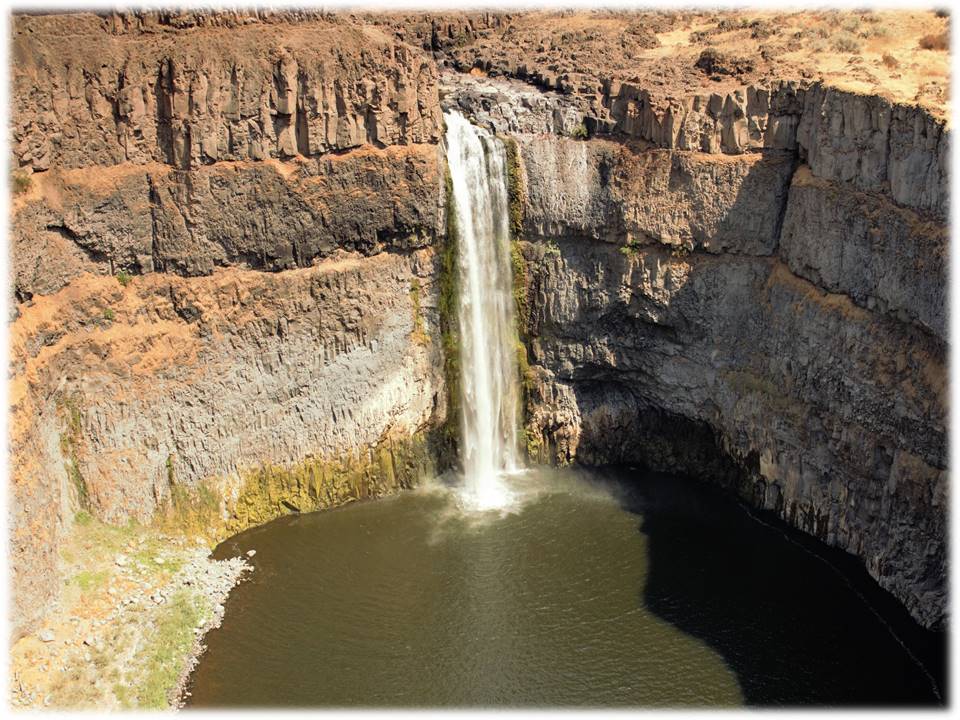
PALOUSE FALLS - Palouse Falls State Park, Washington


On February 12, 2014, Palouse Falls was deemed the official waterfall of Washington State. Meaning "Falling Water", named by the Palouse Indians, the Falls is located within the Palouse Falls State Park.


FALL TYPE: Lying on the Palouse River, plunge pool type Fall dumps 198 feet into a pool that flows into the Snake River. 
INDIAN MYTH: Five giant Wolf brothers with spears fought Big Beaver (who stayed peacefully in its hole in the ground)  killed giant Beaver. Mortally wounded, Beaver died thrashing and clawing the rock to gouge out the cliffs. When it died, its heart turned to stone.


ACCESSIBILITY: Trails for hikers lead to the base of the Falls. 0.5 miles of ADA paved paths lead to several overlooks, kiosks full of information about the park and the creation of the canyon, pit toilets, and unsheltered picnic tables.


DIRECTIONS: From Washtucna, drive SW on Main Street for 6.5 miles. Turn onto WA-261S. Follow the signs to Palouse Falls State Park. The highway winds through the country-side for 8.5 miles. You will think you are traveling incorrectly because the area is "open range". The Palouse Falls State Park road is on the left with a clearly marked sign. Travel 2.4 miles on a dirt and gravel road. The parking lot with handicap parking signs and restrooms are at the end of the road.


Tuesday, December 13, 2016

DOANES FALLS - Royalston, Massachusetts


In the 19th century, Amos Doane owned the land and a four-story tall manufacturing mill of doors, sashes, and blinds that sat on the falls.  Later aftser the Doane's mill failed, several mills-grist, saw, pail, and falling-operated successfully on the falls. 
WATERFALL TYPE: The waterfalls cascade over boulders, flat granite, and small islands at several points on the Lawrence Brook before plunging into the Tully Lake.
ACCESSIBILITY: Trails lead down both sides of the stream. Two types of trails lead to the upper falls and lower falls. Moderate to strenuous trails lead to viewing points and to the base of the falls; however, trails marked as handicapped with handicapped signs are smooth. The trails lead directly to viewing areas.


ADDRESS/DIRECTIONS:
Athol Road
Royalston, MA 01368
Telephone: 978.248.9455
Tully Lake Campground:  978.249.4957 (seasonal)
Email: central@thetrustees.org

From Rt. 2, Exit 18, follow Rt. 2A West into Athol. At intersection with Rt. 32, cross Miller’s River Bridge and bear right onto Chestnut Hill Rd. (becomes Athol Rd.) north toward Royalston. Proceed 4 mi. to entrance and parking (3 cars) on left. To Coddings Meadow at Lawrence Brook, walk 0.5 mi. down gated woods road off Athol Rd. on right just before stone bridge.

Saturday, November 26, 2016

KENT FALLS STATE PARK - Kent, Connecticut

Kent Falls is one of the most fabulous waterfalls in the New England states dropping 200 feet in 1/4 mile before flowing into the Housatonic River.


This oldest state park in Connecticut was a gift to the state from the White Memorial Foundation in 1915.


The area is named "Sactacook" after a small Indian tribe that originated in Southwestern Connecticut.

ACCESSIBILITY: Handicap parking signs are at the head of the paved trail that leads through the covered bridge and onto the waterfall. At the base of the fall, a flat stone platform provides a serene view of the fall.

FALL TYPE: Cascade: Water descends a series of rock steps.

ADDRESS: 159 Macadonia Brook Road  Kent, CT  06757

DIRECTIONS: North on Rte 7, 4.5 miles from Kent

Friday, November 25, 2016

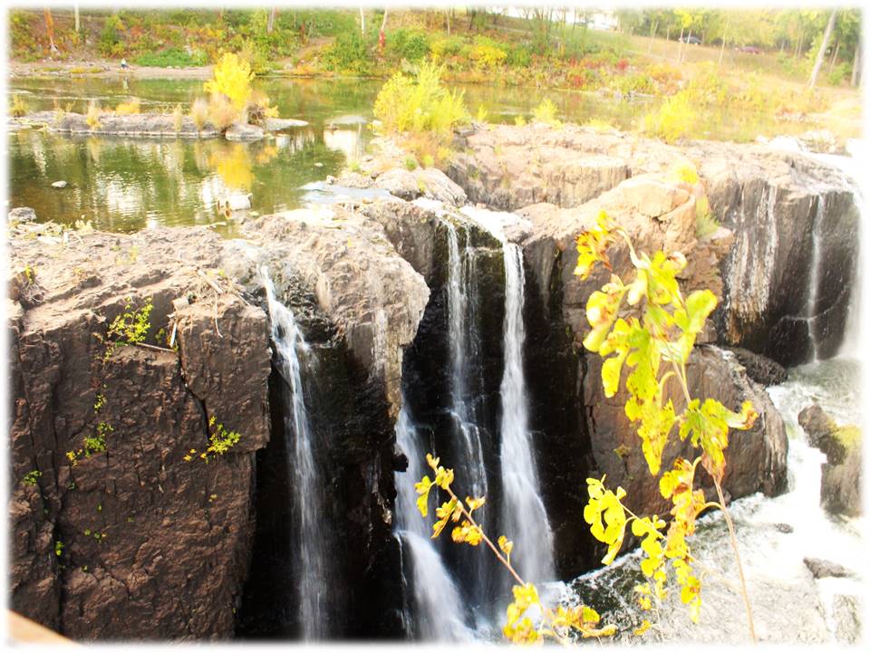
GREAT FALLS - Paterson, New Jersey


Amidst the town of Paterson, New Jersey, a 77-foot impactful waterfall on the Passaic River powers the Great Falls in Paterson National Historical Park. Alexander Hamilton proposed early development of the water power system for industrial use which began in 1792.


Great Falls is one of the largest waterfalls in eastern United States.


We captured the famous Fall's rainbow as we crossed the footbridge over the chasm. 


ACCESSIBILITY:  The parking lot on McBride Street offers handicap parking and ramps at designated handicap parking signs.sidewalks, ramps, and bridges circle the entire park. An accessible bridge crosses over the waterfall and gorge.


WATER SOURCE/FALL TYPE: Passaic River/Plunge: Water descends vertically, losing contact with the bedrock surface.


PHONE: (973)523-0370


ADDRESS:72 McBride Avenue, Patterson New Jersey

Tuesday, October 11, 2016

FALLING SPRINGS CREEK - Chambersburg, PA


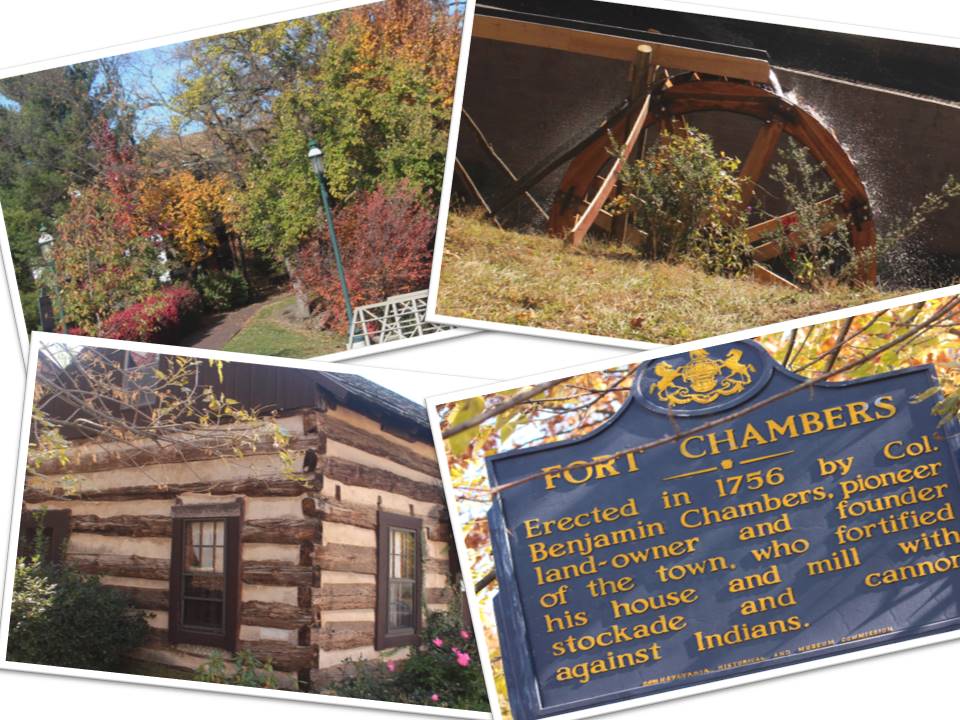
In the middle of the Civil War rich colonial town of Chambersburg, Pennsylvania is a small park call Fort Chambers Park. Falling Spring Creek flows into the Conococheague Creek. Conococheague Creek starts in Chambersburg, and then flows into the Potomac River.


Benjamin Chambers Fort (1756-1760) was a settler's stone house, sawmill, and gristmill surrounded by a stockade.

The old water wheel was part of the original Gristmill.


ACCESSIBILITY: Starting at the parking lots handicap parking sign, paved walkways and bridges cross the springs. Observation areas allow a closer look at the water wheel and waterfall.


ADDRESS:Borough of Chambersburg
100 South Second Street
Chambersburg, PA 17201
p 717-264-5151