Welcome note

When my husband and I set out to find and take pictures of wheelchair accessible waterfalls in every U.S. state, we were excited about the challenge. We gave ourselves no time limit to accomplish our feat; however, we had one mutually agreed upon rule that dictated how long we would stay in any given area. That rule was to never shiver again. Needless to say, adhering to this rule presented a new challenge. The new challenge was to find a waterfall that was actually flowing. Visiting mid-west and eastern states during months that prevented us from shivering are the same months that are hot enough to dry up streams; hence, little or no water flow for waterfalls. The natural scenery and picturesque landscapes warrant a second visit in the early spring right after the snow melts.

Bob and Jan

Bob and Jan
Christmas Eve

Total Pageviews

Showing posts with label waterfalls. Show all posts

Tuesday, October 11, 2016

MUDDY CREEK FALLS - Swallow Falls State Park, Maryland


Nine miles north of Oakland, Maryland is Swallow Falls State Park. Among the many tall Hemlocks, Maryland's tallest waterfall crashes fifty-three feet. Muddy Creek Falls is on the Youghiogheny (pronounced: Yawk-a-gheny) River and Toliver Creek.

ACCESSIBILITY:  Handicap parking is available at the ramp that leads to the fall's overlook platform. Handicap parking and accessible bathrooms are at a parking lot beside the fee booth located at the park entrance.

FEE:  The Saturday of Memorial Day weekend through Labor Day, as well as weekends in May, September and October $3/person for Maryland residents, $5 for out of state residents. All other times $3/car for Maryland residents, $5/car for out of state residents.
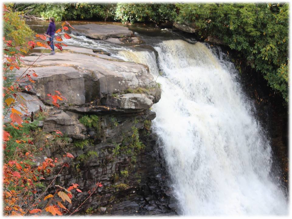
TYPE:  Punchbowl - Water descends in a constricted form and then spreads out in a wider pool.


Cascade - Water descends a series of rock steps.
Tidbit:  1,917 acres were donated by John and Robert Garrett of Baltimore to be used as a state forest. Also, in 1918 and again in 1921, Henry Ford, Thomas Edison, John Burroughs and company encamped by Muddy Creek Falls.


DIRECTIONS:  Follow Rt. 219 south 19.5 miles to Mayhew Inn Road (2 miles past Deep Creek). Turn right on Mayhew Inn Road, travel 4.5 miles to end of road. At the stop sign turn left onto Oakland Sang Run Road, travel 0.3 miles to first road on the right which will be Swallow Falls Road. Turn right onto Swallow Falls Road and travel 1.3 miles to Swallow Falls State Park.

ADDRESS: Swallow Falls State Park
                     222 Herrington Lane
                     Oakland, MD 21550 
                     ​301-387-6938​

Thursday, September 29, 2016

NIAGARA FALLS - Niagara Falls State Park, New York


DESCRIPTION:  Lake Superior, Lake Michigan, Lake Huron, and Lake Erie overflow into Lake Ontario. About 150,000 gallons of water/second floods over the America side of Niagara Falls. The height is 176 feet.  Niagara Falls State Park is the oldest state park in America.

Besides the spectacular scenic views of the falls and the experience of the mist at many points in the park or hearing the Fall's roar which makes it nearly impossible to carry on a conversation in a normal voice volume, the park offers dining, Cave of the Winds tour, Legends of
Adventure movie (meet daredevils traversing the Falls), sea life at the Aquarium of Niagara, and boat rides to the bottom of the Falls on "Maid of the Mist", as well as a touring shuttle.

In the late 1860's, a small group of environmentalists founded the Free Niagara movement. The movement wanted the natural beauty of the land surrounding the falls to be protected and remain free to the public. The entire network of paths through the wooded areas and along the banks of Niagara River stays maintained and preserved. Even though the park entrance is free, a $10 parking fee is due upon exiting.
 
 TYPE:   Plunge: Water descends vertically, losing contact with the bedrock surface.  Block: Water descends from a relatively wide stream or river.
 
ACCESSIBILITY:  Wheelchairs and strollers are available at the welcome center.  Level pathways and elevators are available for easy access to anywhere in the park. The trolley and "Maid of the Mist" are accessible for wheelchairs. The 230-foot Observation Deck has elevators to the top overlook and to the base of the falls. Accessible pathways lead to the base of the falls to experience the massive amounts of mist.


DIRECTIONS:  After crossing Grand Island Bridge ($1 toll), take exit 21 to Robert Moses Parkway. Continue on the Parkway as it turns into Prospect Street. Follow the signs that direct you to Niagara Falls State Park parking lots.

Phone:  (716) 278-1796
Address:  Niagara Falls State Park
                332 Prospect Street
                Niagara Falls, NY  14303


Thursday, July 14, 2016

BOND FALLS - Paulding, Michigan


DESCRIPTION:  Bond Falls, western U.P. Michigan, is in southern Ontonagon County. It falls over a thick formation of fractured rock. The total fall is approximately 50 feet; located in the middle branch of Ontonagon River.


ACCESSIBILITY:  Paved paths lead directly from the parking lot to a large boardwalk that raps from one side of the falls to the opposite side in a half moon shape.  Incorporated at six points on the horseshoe, three special viewing areas allow for seating or clear views. Able-bodied people can take steps to the top of the falls.


TYPE:  Cascade: Water descends a series of rock steps.

DIRECTIONS: In the town of Paulding, Michigan (unincorporated), turn off the main road (45) onto Bond Falls Road. Drive four miles to the Bond Falls sign located on the left side of the road.  A $9.00 day fee is required for out of state vehicles upon entrance: payable at the ranger's booth.

Bond Falls Road
Paulding Michigan  49912
906-353-6558

Tuesday, June 28, 2016

Tahquamenon Falls - Tahquamenon Falls State Park, Michigan


Tahquamenon (pronounced like phenomenon) Falls is located in the eastern upper peninsula of Michigan. Tahquamenon River flows into a bay on Lake Superior. It's copper color is caused by tannin from cedar swamps draining into the river.


Accessibility: Paved pathways lead to several viewing areas of the upper falls. Steps lead to the lower falls.
Fall Type: Plunge: Water descends vertically, losing contact with the bedrock surface. The fall is 200 feet across with a drop of 48 feet. The Fall is one of the most voluminous waterfalls east of the Mississippi River, with Niagara Falls being the most.

Directions: Follow M-123 north of Newberry, Michigan for approximately 22 miles. The Upper Fall Tahquamenon State Park sign is on the left. The park is located on the right. Out of state vehicles pay a $9.00 day-pass fee or $31.00 year-pass.

Sunday, December 27, 2015

Willow Falls - Willow River State Park, Wisconsin


DESCRIPTION:  Willow Falls is a 45 foot cascading waterfall located in Willow River State Park northeast of Hudson, Wisconsin.

ACCESSIBILITY:  The falls are reachable by several different trails. The trails are accessible; however, they aren't easily accessible. The  shortest trail is on a 1/4 mile paved walking path; however, it is a steep trail.  The trail we took to the waterfalls was grassy in spots, deep gravel in other spots, then other spots had gouged out muddy areas. My husband and step-son took turns pushing my wheelchair over this terrain.  I could have never successfully mastered the feat alone.  When leaving the falls, we took the third trail.  This trail was about two miles, but, a bit smoother.  It was a dirt path, but well-worn because this path was used more frequently by the many people who visited the fall each day. Even though the trails left little-to-be-desired, the nature was worth the travel.

A sturdy bridge traversed the 100-foot wide waterfall. A parking fee is payable upon entering the park.

TYPE:  Cascading - follows along a series of rock steps

Sunday, September 20, 2015

BRIDAL VEIL FALLS - PROVO, UTAH

DESCRIPTION - Bridal Veil Falls is a 607 foot tall, double cataract fall in Provo Canyon, Utah. Until 2008 the tramway was heralded as the steepest aerial tramway in the world, but the cables were cut. The falls can be seen in several scenes in the 1982 movie Savannah Smiles. A year-round stream of water surges from a narrow point at the top from several springs.


 ACCESSIBILITY - Picnic tables are available in the park under shade trees and close to the falls. Paved paths make the short trek to the falls easy and casual. Bikers and skateboarders of all ages use the wide path for exercise as well.


  FALL TYPE - Cateract - A descent of water over a steep surface


DIRECTIONS -
  • Located up Provo Canyon (Hwy. 189) Provo, UT 84604
  • Phone: (801) 852-660

Sunday, September 13, 2015

RIFLE FALLS STATE PARK - RIFLE COLORADO

Description - Rifle Falls State Park is in Colorado NE of Rifle, Colorado. Thev48-acre park has a triple waterfall. The falls is a lush area of trees and greenery kept moist by the spray of the cascading triple waterfall (http://cpw.state.co.us/placestogo/parks/RifleFalls).  Mysterious limestone caves beneath the falls entice spelunkers and other curious visitors to explore their dark depths.Spray from the falls can be felt while picnicking at the tables near the falls.  


Accessibility - "In 1998, the park underwent a face-lift: new pavement, picnic tables, interpretive signs and increased handicapped access." The trek to the falls is only a short jaunt from the parking lot. 


Address and directions -  Follow the signs from town. The park is 13 miles north of town. A small fee is required to enter the park. Camping by tent or RV is available. Park Office - 5775 Highway 325 Rifle, CO, 81650  Park Hours - 7AM -10PM. Anglers And Campers Have 24 Hour Access Office Hours - Varies - Can Visit Rifle Gap's Office For Needs 7am - 7pm Daily. Phone - (970) 625-1607 Email - Rifle.Gap.Park@State.Co.Us 

Fall Type - a triple 70-foot waterfall flowing over a travertine (a mineral formed by a compilation of hots or spring waters) dam on East Rifle Creek.

Nature 


Friday, August 14, 2015

PIPESTONE NATIONAL MONUMENT-MINNEWISSA FALLS-MINNESOTA

Pipestone National Monument offers a three-quarter mile trail through the prairie, by quarries, and in front of Minnewissa Falls. Only people of Native American ancestry with a special permit can quarry the area or remove any stone.

WATERFALL TYPE:  Ledge waterfall: Water descends vertically over a vertical cliff, maintaining partial contact with the bedrock


ACCESSIBILITY:  A paved path throughout the park allows a wheelchair user easy access to view the beauty; however, a few places are narrow or a little steep that require assistance from another person.


DIRECTIONS:  Pipestone National Monument is easily accessible from the following highways. When you reach the city of Pipestone, road signs will lead you to Pipestone National Monument.
  • I-90 Luverne, MN Exit north on US Highway 75 to Pipestone, MN - 25 miles
  • I-90 north on MN Highway 23 to Pipestone, MN - 27 miles.
  • Marshall, MN, southwest on MN Highway 23 to Pipestone, MN - 45 miles.
  • Slayton, MN, west on MN Highway 30 to Pipestone, MN - 29 miles.
  • Lake Benton, MN, south on US Highway 75 to Pipestone, MN - 19 miles.
  • I-29 north of Sioux Falls, SD to Exit 109 (Madison/Colman exit) go east on SD Hwy 34 which becomes MN Hwy 30 to Pipestone, MN - 55 miles
  • I-29 Brookings, SD exit, go east on Hwy 14 to Lake Benton, MN, south on US Highway 75 to Pipestone, MN.


Monday, July 20, 2015

FALLING WATERS, OZARKS NATIONAL FOREST-ARKANSAS

DESCRIPTION: This beautiful little waterfall is conveniently located right next to the road, so you don't even have to get out of your car to see it. A narrow dirt path leads to a nice big pool that the falls spill into, and it is a popular swimming hole in the summer.


DIRECTIONS:  At the junction of Scenic 7 Byway and Ark. 16 at Pelsor, turn east on Ark. 16 to Ben Hur, then go south about 1.5 miles until you reach Forest Service Road 1205. Turn east on this road and remain on it for approximately 3 to 4 miles. You'll be following Falling Water Creek and will come upon the falls to your right. They are easily visible from your vehicle.

ACCESSIBILITY:  The falls can be seen from your car directly off the side of the road. A small pull-off area is available with a narrow dirt path leading to the pool that the falls spill into. Getting to the pool would be difficult without assistance.

WATERFALL TYPE: Plunge-descends vertically, losing contact with the bedrock surface.